1. When the height is measured with reference to a give level surface such as mean sea level, it is called a _________________.
a. measurement
b. plumb line
c. leveling loop
d. elevation
2. An acre is equivalent to _________ square chains, and _______________ sq. ft.
3. Add 45°30'47" to 22°37'30"
4. A parcel of land has the shape of a trapezoid, with the base equal to 3000 feet, the other base equal to 2500 feet and the altitude h equal to 400 feet. The value of the land is $40,000 per acre. How much is the parcel of land worth?
5. The vertical angle from level ground to the top of a building is 50°. The angle is measured from a point that is 150 feet from the base of the building. How tall is the building?
6. A point has polar coordinates (111.80, 26.56°). Determine its corresponding rectangular coordinates.
7. A point along a road centerline is located 1320.39 feet from the point of beginning. If the point of beginnings station is 10+00. What is it's station designation?
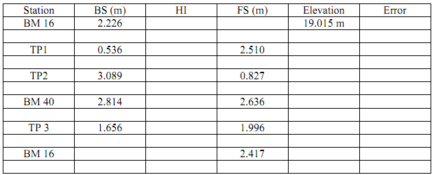
8. Complete the benchmark-leveling field notes shown in the following table by computing and recording the HI and elevation for each TP and benchmark and show leveling error.
9. Trigonometric leveling-If the Rod height was 5.4 feet at the BS (elevation 4700.00), the zenith angle was 62°50'30", the slope distance was 450.00 feet. What is the height of the instrument? Then you turn to a FS and read a zenith angle of 90°12'59" and the slope distance is 380.00 feet, the Rod height was 6.3 feet at the FS, what is the elevation of the point at the FS?
10. Express the following zenith distances (angles) as vertical angles:
a. 80°35'15"
b. 87°14'56"
c. 104°30'40"
11. The magnetic bearing of a boundary line was recorded as S 43°30'E in 1862. At that time and place, the magnetic declination was known to be 3°15'W. Determine the true azimuth and bearing for that line.
12. The U.S Public Land Survey System was developed to:
Avoid errors and confusion that existed in the colonial states
Manage, lease, or sell land in the public domain
Provide a uniform and consistent system for dividing the lands
All of the above
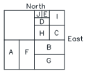
13. Describe parcels E & H using aliquot parts description and calculate the area of each in acres.
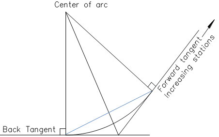
14. Label parts of the following diagram with PC, PT, PI, LC, M, E, R, Δ, L, T
15. For the simple curve with an arc length of 1090.83 feet and a tangent of 606.81 feet, if the station of the PI is 24+57.00, what are the stations of the PC and the PT?
16. For a preliminary vertical alignment of a roadway, the straight tangent sections are established as follows:
Station 10+00.00, tangent elevation = 2889.07
Station 12+69.55, tangent elevation = 2897.82
Station 16+63.64, tangent elevation = 2923.00
Station 20+97.80, tangent elevation = 2906.25
Station 23+30.05, tangent elevation = 2922.29
Determine the gradient of each tangent.
17. BONUS: Given a vertical parabolic curve that has its PVI at station 16+63.64 and elevation at 2923.00. The grade of the back tangent is +6.39%, the grade of the forward tangent is -3.86%, and the curve length is 300 ft. What is the Station and Elevation of the turning point (high point)? What is the Elevation of Station 16+00?