Response to the following multiple choice questions:
Introduction
Note: Please replace the question in the story map (13 Streams and Flooding) with the question below. Use the information under "Topic 1: Introduction" to answer the question. Please disregard the linking article about Jamestown, Virginia.
Question 1: The majority of the world's human population lives on or near a river.
A. True
B. False
2. If our ability to predict floods has improved significantly, why does economic loss continue to rise? (Check all that apply).
A. Increased urbanization
B. Increased population
C. Increased development along coasts
D. Increased real estate values
3. What are/is not a potential outcome(s) or condition(s) resulting from too much nitrogen running off from agricultural fields?
A. Eutrophication of water bodies
B. Decrease in crop production
C. Contamination of groundwater
D. Health issues in infants
4. Which is not a way humans contribute to stream bank erosion?
A. Vegetation removal
B. Increase in impervious surfaces
C. Wave action from boats
D. Wind erosion of exposed banks
5. What impacts do dams have on the transportation of sediment? (Check all that apply).
A. Water upstream of the dam will increase in flow velocity and erode sediment.
B. Water upstream of the dam will decrease in flow velocity and deposit sediment.
C. Water immediately downstream of the dam will have a high sediment load and deposit sediment.
D. Water immediately downstream of the dam will be relatively free of sediment, and the river will erode its bed and banks to reestablish its missing sediment load.
Global Perspectives
Questions 6, 7, 8, & 9 introduce you to cities located along major rivers. These questions are multi-part and are formatted as short answer questions in the D2L quiz.
- Questions 6-8: list the capital letter of the multiple choice option that corresponds to the appropriate city, followed by the capital letter of the multiple choice option that corresponds to the appropriate river. List the capital letters only; do not include the city or river names. Do not include periods or spaces between, before, or after the answers.
- Question 9: Provide your answer in the same format used for questions 6-8. List the capital letter that corresponds to the appropriate latitude, followed by the capital letter that corresponds to the appropriate longitude, followed by the capital letter that corresponds to the appropriate river. List the capital letters only.
6. City, River? Hint: For #6 and the other questions in this section, note that you may have to zoom out to see the city label after you arrive at a coordinate location in the story map.
City:
A. Atlanta
B. Baghdad
C. Cairo
D. Dusseldorf
River:
A. Mississippi
B. Euphrates
C. Tigris
D. Nile
7. City, River?
City :
A. Paris
B. Moscow
C. Cairo
D. Shanghai
River:
A. Ohio
B. Jordan
C. Zambesi
D. Nile
8. City, River? Hint: rather than clicking on the yellow line to determine the river name for #8, zoom out and determine the river name using the labels shown on the story map.
City:
A. London
B. Madrid
C. Paris
D. Buenos Aires
River:
A. Rio de la Plata
B. Seine (La Seine)
C. Thames
D. Volga
9. Montreal, Canada. Latitude, Longitude, River? Hint: coordinates are displayed in the lower left hand corner of the viewer window in decimal degrees, with longitude given first and latitude given second. You will need to relate the decimal degrees format to degrees, minutes, seconds to answer this question.
Remember, for latitude, locations in the Northern Hemisphere are denoted with an N (or a positive number), while locations in the Southern Hemisphere are denoted with an S (or a negative number). For longitude, locations in the Eastern Hemisphere are denoted with an E (or a positive number), while locations in the Western Hemisphere are denoted with a W (or a negative number).
Latitude: A. 45° 30'S B. 73° 33'N C. 45° 30'N D. 73° 33'S
Longitude: A. 45° 30'E B. 73° 33'N C. 45° 30'S D. 73° 33'W
River:
A. Montreal
B. St. Lawrence
C. Hudson
D. Ottawa
Watersheds and Drainage Density
Hint: Before attempting to slide the time slider widget in-10, zoom in slightly. You should see the Columbia River watershed appear. Dragging the slider to the right will reveal the subbasins.
10. How many Columbia River sub-basins in the United States are displayed on the map?
A. 7
B. 8
C. 9
D. 10
11. What water uses did you see as you traveled upstream on the Columbia River? (Check all that apply). Hint: Assume the reservoirs shown provide some degree of flood control.
A. Agriculture
B. Flood control
C. Power generation
D. Recreation
E. Ranching
12. River A?
A. 1
B. 2
C. 3
D. 4
13. River B?
A. 1
B. 2
C. 3
D. 4
14. River C?
A. 1
B. 2
C. 3
D. 4
15. River D?
A. 1
B. 2
C. 3
D. 4
16. What is the stream density of the Willamette River sub-basin?
A. 12800 / 11500 = 1.11
B. 11500 / 12800 = 0.90
C. 12800 / 11500 = 1.43
D. 11500 / 12800 = 0.95
17. What is the stream density of the Snake River sub-basin?
A. 108000 / 138000 = 0.78
B. 138000 / 108000 = 1.28
C. 108000 / 138000 = 0.83
D. 138000 / 108000 = 1.48
Drainage Patterns
Hint: Questions 18-22 involve identification of drainage patterns. Images for 19-21 are tricky. See the:Drainage Patterns Guidance slides for interpretation tips.
18. Identify Drainage pattern 1.
A. Radial
B. Trellis
C. Rectangular
D. Dendritic
19. Identify Drainage pattern 2.
A. Radial
B. Trellis
C. Rectangular
D. Dendritic
Note: the story map displays the wrong location for drainage pattern 3/question 20. Drainage pattern 3 is shown below. Use the area enclosed by the red line when determining the drainage pattern for this location. Be attentive to the angles of the confluences between trunk streams and their tributaries.
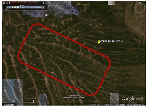
20. Identify Drainage pattern 3.
A. Radial
B. Deranged
C. Rectangular
D. Dendritic
21. Identify Drainage pattern 4.
A. Radial
B. Trellis
C. Rectangular
D. Dendritic
22. Identify Drainage pattern 5.
A. Radial
B. Trellis
C. Rectangular
D. Dendritic
23. Based on the location and the deposition type, explain why this stream forms a braided pattern.
A. The steep slope of the river means that water flows faster and can easily carve out a series of channels forming a braided stream.
B. The slow flowing river means that not much sediment can be carried by the water and hence, the load is deposited forming a braided stream.
C. The channels are stationary and it is the river that moves, thus creating a braided appearance.
D. The steep topography means the river is stationary and it is the channels that are constantly shifting, forming a braided stream.
24. Where does the sediment (deposition material) come from? Hint: When trying to determine the origin for sediment in a given river, it is helpful to look at potential sediment sources upstream.
A. The sediment is actually in place and is not transported. It is merely disturbed by the river, which forms bars of deposited bed load.
B. The sediment was actually deposited upstream by meandering rivers and over time headward erosion by the river created the braided stream.
C. The sediment is from glacial erosion that is carried downstream by streams from the melting glacier.
D. The sediment is finely sorted from upstream weathering and erosion of loess deposits.
Meandering Streams and Floodplains
Note: Review- the stream process animation in the story routes to the wrong animation. An animation with the appropriate content.
Hint: Identify Features A-E. You may need to zoom in and out when inspecting these features.
25. Stream Feature A.
A. Cutbank
B. Meander scar
C. Deep channel (thalweg)
D. Outside of meander
E. Oxbow lake
26. Stream Feature B.
A. Cutbank
B. Inside of meander
C. Point bar
D. Shallow channel
E. Oxbow lake
Hint: if you zoom in too close to Feature C (and Feature E, below), imagery appears from a date with a higher water level when both features were submerged. If you encounter this, zoom out to a perspective where you can see a white to tan feature near the C and E markers. This is the feature you should identify.
27. Stream Feature C.
A. Cutbank
B. Point bar
C. Deep channel (thalweg)
D. Outside of meander
E. Floodplain
28. Stream Feature D.
A. Inside of meander
B. Meander scar
C. Point bar
D. Deep channel (thalweg)
E. Oxbow lake
29. Stream Feature E (Hint: assume E is the white to light tan feature to the northwest of the "E" marker).
A. Cutbank
B. Meander scar
C. Point bar
D. Deep channel (thalweg)
E. Island
30. Identify the dominant land uses surrounding the river.
A.Agriculture
B.Mining
C.Forestry
D.Urban
E.Fishing
31. What is the length, in miles, of the channel? (Hint: measure and report the downvalley, or straight line, distance between X and Y.)
A. 29
B. 16
C. 38
D. 47
32. What is the length, in miles, of the channel? (Hint: measure and report the sinuous distance, that accounts for all of the bends in the channel, between X and Y. Confirm the freehand polyline tool is set to the correct length units before measuring the channel.)
A. 29
B. 16
C. 38
D. 47
33. Use the following formula to calculate the SI for this reach of the Mississippi River. Sinuosity Index (SI) = channel length/downvalley length.
A. 16 / 37 = 0.42
B. 47 / 29 = 1.62
C. 38 / 16 = 2.38
D. 38 / 29 = 1.31
34. Compute the SI of the San Juan River from point A to point B.
A. 20 / 4 = 5.0
B. 6 / 10 = 0.60
C. 6 / 2 = 3.0
D. 8.5 / 3 = 2.83
35. Which river (Mississippi River or San Juan River) has a higher SI?
A. Mississippi River
B. San Juan River
C. They have the same
D. Unable to discern
36. Explain why there are no classic oxbow lakes or meander scars.
A. They have been filled in by sediments from the river
B. The surrounding material is too soft to allow for their creation
C. The surrounding material is too hard to allow for their creation
D. The river is downcutting faster than it can change course